
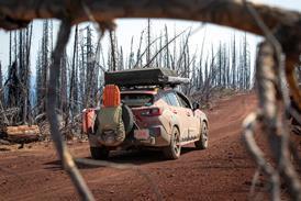


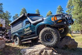

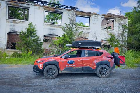
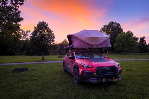
In a world demanding speed and efficiency, we chose the opposite path. Our 29-day, 7,163-mile TransAmerica Trail adventure from Atlantic to Pacific proved that sometimes the slowest route offers the richest rewards. This first installment chronicles our eastern section journey through storm-ravaged Appalachia in a modified 2025 Subaru Crosstrek Wilderness.
Today’s world demands multitasking, getting things done swiftly, and traveling as easily and quickly as you can from point A to point B. But what if you threw that all out the window and saw rural parts of the entire United States off-road, the slowest way possible?
My husband and fellow OVR Features Editor, Andy Lilienthal, and I conquered the TransAmerica Trail from the Atlantic to the Pacific ocean. Did we encounter floods, bugs, mud, and more? Yep. How about wildfires, severe storms, as well as extreme heat and humidity? You bet.
But, after 29 days and 7,163 miles of challenges with rough roads—3,184 miles being endless off-pavement stretches, we’d do it again in a heartbeat.
This is the first of a three-part installment about our journey piloting a slightly modified 2025 Subaru Crosstrek Wilderness across the country.
Part one dives into the trail’s eastern section as we drove this Subaru on this epic overland adventure. Buckle up as we take you on our East Coast jaunt: Days 1 through Day 7 from TAT’s official start in Nags Head, NC to Fireside Camp and Lodge in Sesquatchie, TN.
What is the TransAmerica Trail?
The TransAmerica Trail (TAT) is a trans-continental compilation of routes linking both coasts with a few offshoots along the way. Adventurers typically use dual-sport motorcycles or high-clearance 4x4s.
However, with proper planning and the right gear, coupled with our extensive off-roading backgrounds, we successfully completed TAT in a properly prepared all-wheel-drive Subaru Crosstrek Wilderness.
TAT primarily utilizes small paved public roads and off-pavement tracks. A few private property owners have also given permission for travel on their properties. Andy was the driver; I was the navigator.
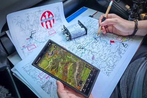
I used a few different methods of navigation to make this overland trip happen. We bought GPX tracks as well as paper maps and turn-by-turn roll-chart directions from TAT’s website.
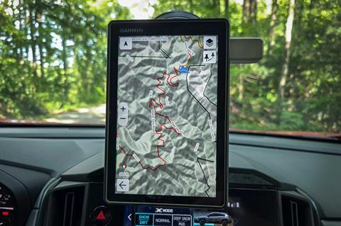
Andy stitched individual GPX tracks together to make one long track, and displayed it on our Garmin Tread - Overland Edition inReach device.
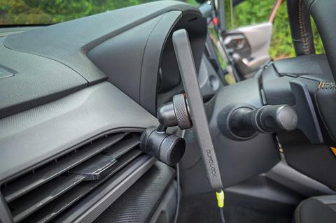
We also used the onX off-road app to help track trail conditions, dispersed camping areas, BLM land or private property boundaries, and more. We secured smartphones via Quad Lock device mounts.
I combined technology as well as paper maps and turn-by-turn directions. This created a comprehensive navigational package.
We also brought along a Starlink Mini packed in a Pelican case, powered by an EcoFlow DELTA 3 Plus power station and 800W Alternator Charger.
We used the Starlink Mini to avoid severe storms, double-check camp areas and route details, and catch up on emails and social media as we were without internet/cell service most of the time.
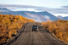
Andy and I started TAT with the Atlantic Ocean Spur segment, just east of Roanoke Island, NC. After that we ran the main east-to-west TAT section until we finished with the Pacific Ocean Spur, ending our long-distance endeavor in Port Orford, OR a month later.
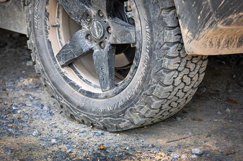
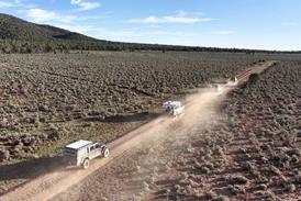
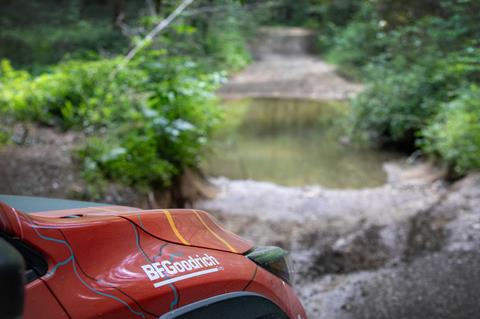
We averaged a not-so-speedy 25 miles per hour during our trip’s entirety and put our BFGoodrich KO2 all-terrain tires and Primitive Racing skid plates to the ultimate real-world test.
Days 1-3: Nags Head, NC to Cavitt’s Creek Park North Tazewell, VA
After touching the Atlantic Ocean at TAT’s start in Nags Head, NC, we mainly traveled small, paved country roads.
We knew the East Coast didn’t have many off-road opportunities, so we used this tarmac time to find our rhythm, dial in equipment and gear, and settle in for one heck of an upcoming journey.
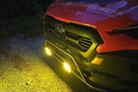
The eastern TAT route had the most pavement of our journey. The roads were tight, narrow, hilly, and winding. If we hit dusk or dusty conditions, a quick flick of a switch turned on our Baja Designs XLR-Pro LED aux lights which were mounted on a Rally Innovations light bar mount.

As soon as we started our trip in North Carolina, we dodged severe storms as we wound our way through Appalachia. These storms pummeled areas with 60+ MPH winds, big hail, and torrential rain—which flooded already damaged areas.
Many areas we drove through were still being fixed from 2024’s Hurricane Helene. But the storms we’re outrunning tore apart newly built bridges and other areas.
Route deviations quickly began. The paper maps were helpful to understand the overall route and see nearby roads in case we needed to change course quickly.
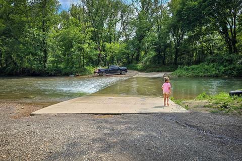
We progressed northwest through NC and deep into VA where we saw the most perfect manicured lawns. We experienced our first creek crossing (of many) and I spotted Andy through a tricky storm-ravaged section of Findlay Gap Dr., near the state’s center.
We finished the Atlantic Ocean Spur in Burnsville, VA, and started the main east-to-west track. We outran or avoided most storms—averaging 18 miles per hour through the picturesque deciduous-lined region.
As we dipped south, TAT trails had interesting names: Archer Run and Hite Hollow Rd. in Virginia’s George Washington National Forest, Troxel Gap Rd., and Tub Run Road in the Jefferson National Forest.
If roads ended in Gap, Branch, or Hollow, we knew it’d be beautiful but a potential challenge. We were in the land of turtles, Subarus (there were tons), and single-finger waves (if you’re lucky enough to see a passersby).
There was little dispersed camping in the eastern side of the country, so I found organized establishments along the way. We ate Mountain House freeze-dried meals or protein-based foods at camp.
We stayed at Twin Lakes State Park in Green Bay, VA, Buckhorne Country Store and Campground Clifton in Forge, VA, and Cavitt’s Creek Park in North Tazewell, VA.
Days 1-3 mileage: 659 (107.7 off-road). Total hours driven: 29 hours. Route deviations off the TransAmerica Trail: 3.
Days 4-6: Cavitt’s Creek Park North Tazewell, VA to Parksville Lake Campground, TN
Appalachia continues to take hold. Collectively, we drove slightly fewer miles at 644 versus 659. However, we increased our off-road mileage from 107.7 to 183.60. Because of that, more rocks became stuck in our rear brakes.
Most eventually popped out on their own through our Reika Seeker wheels, but one stubborn stone screeched for dozens of miles until we popped the wheel off the next morning and dislodged it with a tire iron and flathead screwdriver.
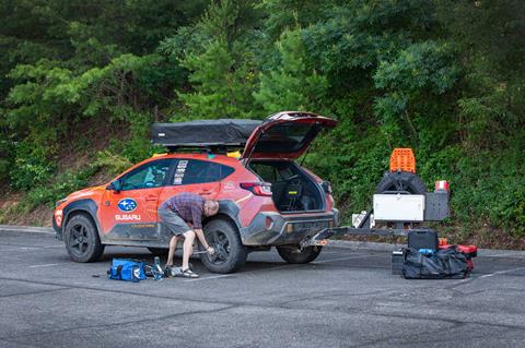
The rock was worn flat and shiny on one side—I’ll make jewelry with the memento. We experienced longer drive days and mitigated more route deviations due to further storm issues and road closures.
This included post Hurricane Helene damage and landslides, too-deep mud holes and water crossings including those on Witt Rd. south of Tellico Plains, TN. There were also huge, downed trees and other storm problems during our first week on TAT.
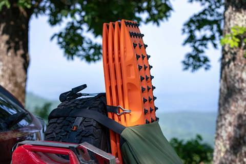
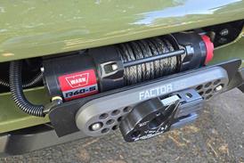
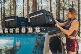
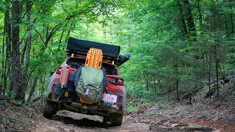
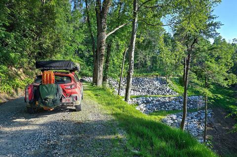
For these exact reasons, we brought along four MAXTRAX XTREME recovery boards (though the company’s new LITE series would work well for Subarus and small SUVs, too).
They’re mounted on a RiG’d Supply UltraSwing Short-Fit swing-out tire carrier that also includes a SideHack extension (for our extra fuel), and a slim UltraTable.
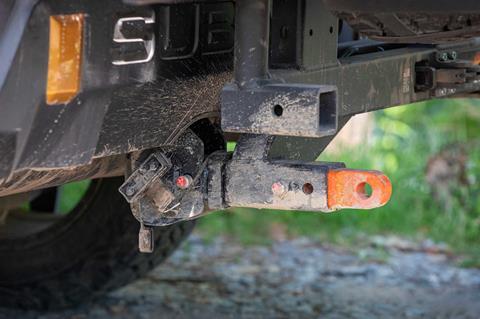
We also had a Factor 55 HitchLink 2.0 rear recovery point in the system and brought along a basic vehicle recovery kit from them, too.
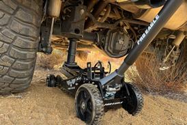
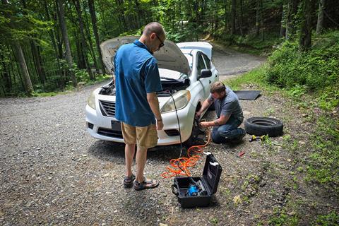
Lastly, we used an ARB single portable air compressor to air up and help a stranded local. We also had their Speedy Seal Tire Patch Kit on hand should we have tire issues (which we didn’t).
Andy and I experienced how remote parts of Appalachia really are as we traversed Maple Sally Road in the Grandfather District of Pisgah National Forest, NC.
This scenic switchback trail totals 20.3 miles. It was overgrown with tall weeds, narrow sections, downed trees, and completely devoid of anyone or anything around.
Huge thanks to the crews who continue to repair this beautiful but ravaged area. We lost count of how many disaster relief grapple trucks and support vehicles we saw.
Severe heat and humidity continued as temps climbed into the 90s and dewpoints hovered in the mid-to-upper 70s. However, the scenery was thick and beautiful with lush trees and brush, a far cry from the tall pines and desert areas we have where we live.
As we battled more severe storms, we traveled through western VA, pushed on to far eastern TN with another route deviation, plus the worst humidity to date. We stuck to our sleeping bags and used wet cooling cloths and an impulse-bought battery-powered fan to help cool us overnight.
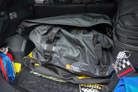
We organized everything in specific places so they each had homes. Our main bags were stowed in strategic areas of the Subaru to help with easy access.
These packs included a Front Runner Outfitters Typhoon Bag for kitchen and camp essentials, a Peak Design Roller Pro for camera and tech gear, and 50L hiking packs for clothing and shoes.
Days 1-6 mileage: 1,303 (291.3 off-road). Total hours driven: 63 hours, 50 minutes. Route deviations off of the TransAmerica Trail: 7.
Day 7: Parksville Lake Campground, TN to Fireside Camp and Lodge, Sesquatchie, TN
After a sweat-soaked sleep, we left eastern TN and dipped into the far northwestern edge of GA, trying to escape the weather.
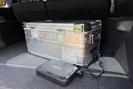
Our ARB Classic Series II fridge was a must-have as it kept food, drinks, and medicine cold. We used an ARB 2.0M Soft Case Awning for shade, too.
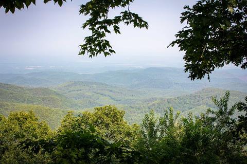
We wound our way around more picturesque trails and arrived at a gorgeous vista: Mill Creek Overlook.
It offered a stunning, secluded view of the Cohutta Wilderness Area, but had the biggest bumble bees we ever saw. They were everywhere.
We continued to lower central TN where we indulged in our first dinner out. I then found Day 7’s camp off the main route: Fireside Camp and Lodge in Sesquatchie, TN.
We outran more storms but got walloped by a heavy thunderstorm at 4:00 am as we laid in our Thule rooftop tent. Thankfully, it kept us dry.
Mileage to date: 1,546 (339.3 off-road). Total hours driven: 75 hours, 40 minutes. Route deviations off of the TransAmerica Trail: 10.
Our First Week on the TransAmerica Trail
After an eventful evening, we awoke and pressed westward, destined to tackle more of Tennessee, then Mississippi, Arkansas, Oklahoma, and the rest of TAT. We realized how different and striking the eastern section of TAT really is.
Thick deciduous trees lined most roads. There were bugs, LOTS of them. Thank goodness for the heat it smartphone device to squelch the itch.

Humidity hung in the air, it was hot, and folks were friendly. Local dogs were mean and attacked our Subaru in many remote areas.
We witnessed over a week of fireflies (lightning bugs) and saw or heard more than a dozen new-to-us birds, which we identified using the Merlin app.
Other than Colorado’s high-elevation mountain trails that reached nearly 13,000 feet above sea level, Appalachia gave us the second-slowest average overall speed.
We got a glimpse of how the eastern part of the United States was handling Hurricane Helene and more recent storm damage.
The resiliency of locals was outstanding. There were many beautiful areas to investigate, as long as the trails were clear and the weather good.
Stay tuned for the second installment of our three-part TransAmerica Trail series. We detail the western half of Tennessee, Mississippi, Arkansas, and Oklahoma! Floods, mud, and more.
Access More Great Stories!
For more informative articles like this, consider subscribing to OVR Magazine in print or digital versions here. You can also find the print edition of OVR at your local newsstand by using our Magazine Finder.


No comments yet